
The Lewis & Clark National Historic Trail travels 4,900 miles across 16 states, including Montana. A Virginia company, Terrain360, is working to cover the entire route with a 360-degree camera, like the one used by Google Street View. This summer, the company floated a section of the Yellowstone River from Livingston to the confluence of the Missouri River to retrace William Clark’s route on the return trip across the country. Prior to this year, Terrain360 had covered about 1,700 miles of the route, including some overland sections like the Lolo Trail and Lemhi Pass, as well as sections of the Missouri River Breaks and the Blackfoot River. Eventually, anyone with a computer can travel the entire route from the comfort of their home, or plan trips based on what they see from the video tour. To learn more about the project and the trail, check out my story athttps://billingsgazette.com/
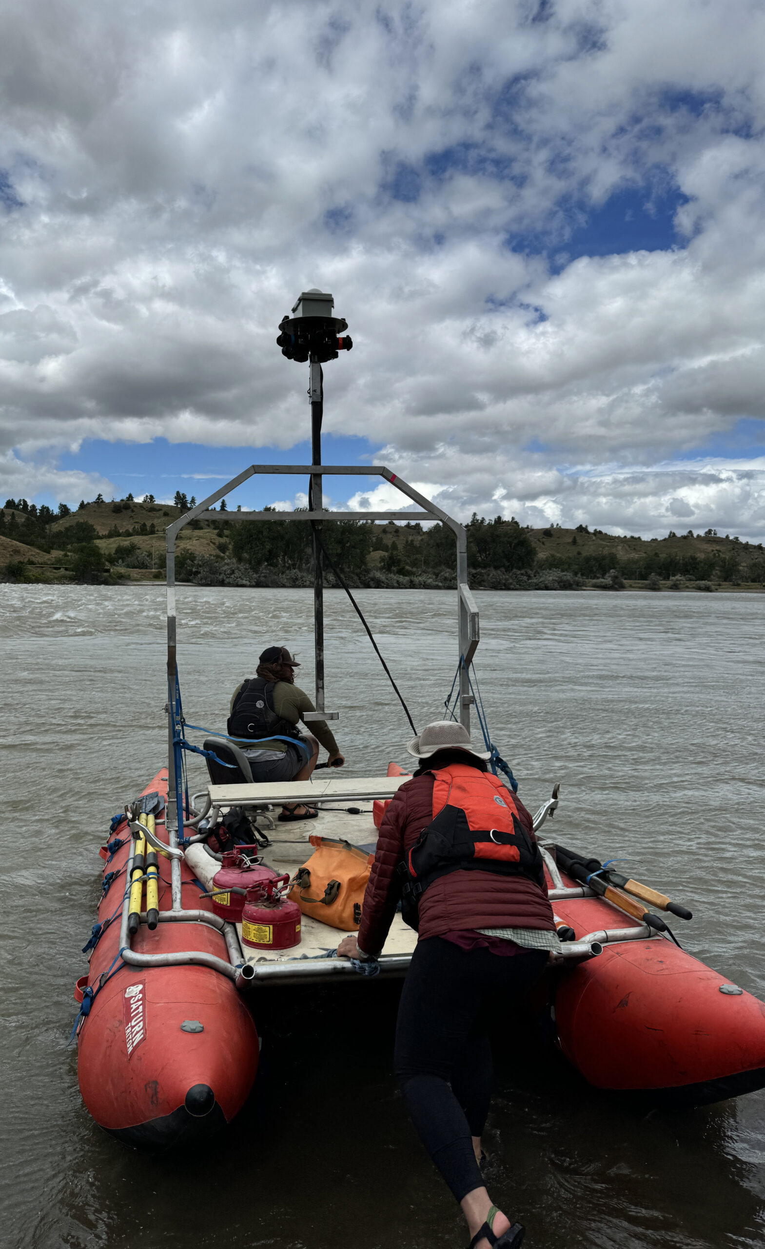
Brett French reports: A 360-degree view of the Lewis & Clark trail

Latest Montana Hunting & Fishing Articles
The Montana Outdoor Radio Show is live Saturday Mornings from 6:06am to 8:00am
MT Waterfowl Hunting
2025-2026 Non-Member Waterfowl & Upland Game Bird Hunting Draft Proposal
Your chance to shape the future of hunting on the Flathead Reservation—share your thoughts on the 2025-2026 draft regulations…
The Department of Livestock Asks Montanans to be Aware of Avian Influenza
A Canada goose was confirmed infected in Gallatin County on February 26.
Get Your Goose on With the Ultimate Goose Jerky Recipe
It’s time to get your goose jerky on!
Trump Jr. Faces International Duck Poaching Probe
Donald Trump Jr.’s hunting trip in Italy just went from a wild adventure to a legal quagmire after he allegedly poached a rare duck—now, the hunt is on for answers.
Montana Hunting
Two sheep test positive for pneumonia-causing bacteria north central Montana
Test results from two rams from bighorn sheep hunting district 622 have tested positive for a microorganism that can cause pneumonia.
Trail of Tears
Montana Grant reflects on aging, adventure, and the urgency of chasing outdoor dreams before the trail gets too steep…
Montana mine one of 10 projects advanced by Trump administration
A proposed Montana mine is one of 10 projects being expedited by the Trump administration to advance domestic critical minerals production.
Three bears killed after woman bitten, dragged from porch
The bears reportedly had previously broken into a vehicle to access groceries and damaged it so badly it was totaled.
K.I.S.S. Turkeys
If you think turkey hunting is just chasing big chickens, wait ‘til one spots you blink at 60 yards… Read more from Montana Grant here…
A Once-in-a-Lifetime Buck at 98
At 98 years old, he didn’t just make a great shot—he made history…
Elk and Deer Permit Drawing Results Are In
Montana’s big game permit results are in—time to find out if you’re chasing dreams this fall or chasing leftovers….
Montana Fishing Reports
Madison River Fishing Report 4.24.25
Spring’s showing off on the Madison—hungry fish, perfect temps, and some serious action if you know where (and how) to look…
Slayer Slays First Salmon of 2025 Season on Peck Thursday
A day of trolling for lake trout on Fort Peck turned into an unexpected and unforgettable catch for “The Salmon Slayer.”
Don Wilkins’ Weekly Fort Peck Fishing Report 4.24.25
Spring is heating up on Fort Peck with walleye, smallmouth, northerns—and even a few surprise lakers—making for a solid week of multi-species action in shallow water.
Montana Ice Fishing
When Ice Fishing Becomes a Rescue Mission
A peaceful day of ice fishing shattered in an instant…
Chasing Ice: For Some, the Season’s Over
Some anglers are stuck dreaming of frozen lakes, while others are packing their gear and chasing the last ice—where do you stand?
LAST ICE HEIST!!!
As Canyon Ferry’s ice fades fast, one last thrilling ice fishing adventure delivers big trout and bigger lessons—before the season slips away! More from Montana Grant here!
ICE DOESN’T CARE!!!
As Montana’s late-season ice thins and conditions become unpredictable, anglers are urged to stay cautious—no fish is worth the risk.
FWP’s Helena Area Reservoirs Fishing Report 3.10.25
Ice conditions are unpredictable, but for those willing to take precautions, the fishing has been excellent across Helena area waters.

Montana Outdoor Podcast
Exclusive Sneak Peek: The Return of the Reservoir Giants with Kit & Trevor Johnson
Think those monster Kokanee were a fluke? Think again—Kit and Trevor are back to spill the secrets before the season heats up!
Sponsors:
MT Outdoor Podcast: The History and Effects of the Introduction of the Cisco into Fort Peck Reservoir
What do deep-water monsters and a double bacon cheeseburger have in common? Tune in to the Montana Outdoor Podcast to find out…
MT Outdoor Podcast Sneak Peek: Downrigger Talks About the Fort Peck Cisco with Andrew McKean
What do a double bacon cheeseburger and Fort Peck’s biggest fish have in common?
MT Outdoor Podcast: Casting Lines and Relationship Goals with the Goodmans
What do you get when a seasoned angler takes his date fishing, forgets to mention the eel-like fish might hug her arm, and somehow still ends up married? Hook into this MT Outdoor Podcast episode to hear it all!
MT Outdoor Podcast Exclusive Sneak Peek: The Couple That Fishes Together…
Get ready to fall hook, line, and sinker for this feel-good sneak peek—love, laughs, and a wild first date with a fish that hugs back…
Outdoor How-To
How To Win the Recall Battle with Your Dog
Tired of playing keep-away with your dog while you’re at hunting camp, fishing, on the trapline or hunting? Even well-trained dogs have their moments! Learn the secret to achieving total recall—no chasing required!
A Feud Over Filleting Has The Internet Debating the ‘Right’ Way to Clean a Pike
When it comes to filleting a northern pike, the internet has spoken—and, as usual, everybody is right and wrong, simultaneously….
How To Master the Art of Finding Antlers
Whether it’s sharp eyes, pure skill, or just a dog with a better nose, shed hunting success is up for debate—but this video might just tip the odds in your favor…
MT Wildlife
When Guests Are Cold-Blooded and Uninvited
When your Ring doorbell says there’s someone at the door, you just never know what to expect in Florida…
Reed Slough Wildlife Viewing Area near Kalispell opens to public
On Saturday, Montana Fish, Wildlife & Parks’ Director Christy Clark, FWP staff and local stakeholders cut the ribbon on the brand-new Reed’s Slough Wildlife Viewing Area.
Bobcat Claws and Chaos
Forget Netflix thrillers—this bobcat vs. squirrel showdown has better stunts and zero CGI….
Montana Tourney Trail
2025 Spring Mack Days – Week 6 Update
Only 19 fish away from a record-breaking Spring Mack Days — and with $225,000 in prizes still up for grabs, it’s not too late to reel in your shot at glory!
Viral Stories
In 1916 They Blew Up A Yellowstone Grizzly Bear with Dynamite After it Killed A Man
In 1916, Yellowstone National Park recorded its first officially documented fatal grizzly bear attack. The victim, Frank Welch, a 61-year-old […]
Irish Woman Sues Wyoming Dude Ranch After Bear Spray Incident Leaves Her Injured
An Irish woman, Lorraine Learmont, has filed a lawsuit against the Triangle C Ranch near Dubois, Wyoming, following an incident […]
Watch This Elk Play a Friendly Game of Backyard Soccer
This smart and friendly elk has serious footwork when it comes to soccer.
Montana FWP
Anglers charged by grizzly bear in Centennial Valley
Fortunately, anglers were unharmed
2025 Fort Peck walleye spawn FINAL update, April 20th
Warm water temps have sparked a major surge in walleye activity—and the numbers coming out of Fort Peck might just surprise you.
Wild Game Recipes
Cheesy Pull Apart Venison Meat Ball Bombs Recipe
Venison, cheese, and biscuits come together in one bite-sized, pull-apart appetizer that’s almost too good to share…
Walleye Rolls
It’s spring spawning season in Montana, and while fish are busy making the next generation, you can turn your catch into a delicious (and safe!) feast with this stuffed filet recipe that lets the good filets roll. Read more from Montana Grant here…